Volcano Watch: Separating signals. What matters to seismologists? : Maui Now
[ad_1]

by Research Corporation of the University of Hawai‘i seismic analyst Maddie Hawk
*Volcano Watch is a weekly article provided by US Geological Survey Hawaiian Volcano Observatory scientists and affiliates.
Whether they originate above or below the Earth’s surface, a wide array of signals appear on the USGS Hawaiian Volcano Observatory’s earthquake-detecting (seismic) data streams. Part of a seismic analyst’s duty is identifying normal versus irregular seismic activity.
Being able to distinguish between random signals and volcanically induced seismic activity allows USGS Hawaiian Volcano Observatory seismologists to keep a closer eye on what matters, the volcanoes.
Seismic signals can be divided into two categories: natural Earth processes and anthropogenic, or human caused, signals. The more stations that a signal reaches, the more likely it is that signal originated due to underground Earth processes. For example, a strong enough earthquake will reach many, if not all seismic stations on the island. Conversely, if only a few stations close to each other record a signal, it is likely that the source is anthropogenic or not volcanically related (for example, a quarry blast or a rockfall).
There are several common anthropogenic signals that HVO seismologists see daily. One of the most frequent and easiest to identify are helicopters. Sound waves from a flying helicopter are strong enough to affect seismometers on the ground. Although they might be hard to identify on a seismogram—which shows ground motion recorded over time by a seismometer as wiggly lines—helicopters are easily revealed in a spectrogram—which shows the frequency spectrum recorded by a seismometer over time.
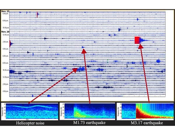
Spectrograms use colors ranging from deep blue to red to represent the strength, or loudness, of a signal. The figure here shows a helicopter’s noise recorded on a spectrogram in comparison with that of a few local earthquakes. The helicopter noise on the spectrogram is light blue, meaning it is much less intense than the strong red signal of the magnitude-3.17 earthquake.
Other anthropogenic signals, like foot and vehicle traffic, can appear noisy and undiscernible, but they are still very different from volcanic seismicity. Within Hawaiʻi Volcanoes National Park, signals like these usually occur in high traffic areas near seismometers but disappear at night.
The top half of the seismogram shown here (6 p.m.–6 a.m. HST) is much quieter than the bottom half (6 a.m.–6 p.m. HST). This diurnal cultural noise, defined as noise from human activity repeated on a daily basis, can mostly be ignored. When analysts at HVO see a signal they don’t recognize, it is helpful to note whether the signal occurred during daylight hours and how many stations “saw” the signal.
The ability to identify and ignore anthropogenic noise allows seismic analysts to pay more attention to the signals coming from volcanoes. VT, or volcano-tectonic earthquakes, usually occur due to a slip on a fault in a volcano; the locations of these earthquakes can give us clues about changing stresses due to magma movement within a volcano.
A typical local VT earthquake is easy to identify in a seismogram, with its sharp, sudden arrival and a tail that tapers off. A higher magnitude earthquake will appear deeper red on a spectrogram, while lower magnitude earthquakes range from green to yellow. Besides an earthquake’s tell-tale shape, seismic stations across the island will record the same event if it is large enough. For example, a magnitude-3.5 earthquake originating below Kīlauea will show up a few moments later and slightly weaker at Mauna Loa seismic stations.
Much like how scientists used to locate earthquakes using seismic wave travel times, HVO has an automated system that calculates the location and magnitude of each earthquake using information from as many stations as possible. However, there are sometimes errors associated with the automated system so HVO’s seismic analysts check all events larger than around magnitude-2.
Seismologists also cannot rely on the automated system to catch every signal. Magma and other fluids move around within the underground volcanic system, resulting in a sort of quiet gurgling very different from VT noise. Volcanically induced LP (long period) events are lower frequency, last much longer, and are less common than VT events. Though these signals are important to monitor, the movement of magma is not always an indication of an imminent eruption. When VT and LP events occur together, say below the summit of Kīlauea, seismologists at HVO might raise awareness of the potential for an eruption.
January is Volcano Awareness Month on the Island of Hawai‘i! Join us this coming week for a guided hike at the Kahuku Unit of Hawaiʻi Volcanoes National Park at 9:30 a.m. on Jan. 7, an After Dark in the Park Program on Kīlauea’s recent summit eruptions in Hawai‘i Volcanoes National Park at 7 p.m. on Jan. 9, or for “talk story” at Nāʻālehu Public Library from 1-4 p.m. on Jan. 10. The full schedule of programs being offered on the Island of Hawai‘i as part of Volcano Awareness Month.
Volcano Activity Updates
Kīlauea is not erupting. Its USGS Volcano Alert level is ADVISORY.
Unrest in Kīlauea’s summit region continues to wax and wane with fluctuating input of magma to the area. An earthquake swarm on Dec. 29-30 south of the caldera was accompanied by inflation shown on the Sand Hill tiltmeter—located southwest of the caldera—indicating a likely intrusive event in the area. The Uēkahuna tiltmeter—located northwest of the caldera—shows little net tilt over the past week. Unrest may continue fluctuate and eruptive activity could occur in the near future with little or no warning. The most recent sulfur dioxide (SO2) emission rate for the summit—approximately 80 tonnes per day—was measured on Dec. 28.
Mauna Loa is not erupting. Its USGS Volcano Alert Level is at NORMAL.
Webcams show no signs of activity on Mauna Loa. Summit seismicity has remained at low levels over the past month. Ground deformation indicates continuing slow inflation as magma replenishes the reservoir system following the 2022 eruption. SO2 emission rates are at background levels.
Five earthquakes were reported felt in the Hawaiian Islands during the past week: a M3.1 earthquake 14 km (8 mi) S of Volcano at 6 km (4 mi) depth on Jan. 3 at 8:12 p.m. HST, a M2.9 earthquake 6 km (3 mi) SSW of Volcano at 1 km (0 mi) depth on Dec. 30 at 10:54 p.m. HST, a M2.4 earthquake 8 km (4 mi) SSW of Honoka‘a at 13 km (8 mi) depth on Dec. 30 at 9:47 p.m. HST, a M2.4 earthquake 7 km (4 mi) WSW of Waimea at 6 km (4 mi) depth on Dec. 29 at 11:34 a.m. HST, and a M4.4 earthquake 7 km (4 mi) SE of Pāhala at 12 km (7 mi) depth on Dec. 28 at 3:16 p.m. HST.
HVO continues to closely monitor Kīlauea and Mauna Loa.
Visit HVO’s website for past Volcano Watch articles, Kīlauea and Mauna Loa updates, volcano photos, maps, recent earthquake information, and more. Email questions to [email protected].
[ad_2]
Source: Maui News